
In textbook chronicles, the “quantitative revolution” marked a historical moment when geography became a true Cold War science. As a result of the Second World War, a new generation of geographers left their parochial disciplinary […]
Címke: Walter Christaller

Tracing the Global History of the Quantitative Revolution: The Transnational History of Central Place Theory
My book project is about the global histories of the “quantitative revolution” in geography. The quantitative revolution has been an epochal textbook chapter in geography’s canonical history, when the discipline transformed into a rigorous social science backed by predictive mathematical methods in the early Cold War. An iconic scientific concept of this quantitative movement, most notably related to Walter Christaller (1933) and August Lösch (1939), was central place theory (CPT). With the globalization of the quantitative revolution after its emergence from the Second World War in the United States, location theories such as CPT became widespread in urban and regional planning across the world. How did quantitative spatial analysis and planning develop in different parts of the world? In what different geographical contexts were location theories like CPT read, reinterpreted, applied, and mobilized? How were these often very different contexts connected? This book offers to fill this significant gap in geography’s twentieth century global history by deconstructing the mainstream Anglo-American narrative and tracing the quantitative revolution through the circulation and local applications of CPT in the “Second” and “Third” worlds and into the pre-Cold War era.
Two new abstracts sent to ICHG2018 and AAG2018
I have sent two abstracts to the 17th International Conference of Historical Geographers in Warsaw, July 15–20 and one – the latter abstract here provided – to the Association of American Geographers Annual Meeting in New Orleans, April 10–14 in 2018.
Historical geographies of the “quantitative revolution”: Towards a transnational history of central place theory
“The Ghana job”: Opening Hungary to the developing world
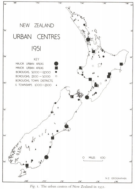
The urban hierarchy of New Zealand in the 1950s
The great Ron J. Johnston wrote an article in 1969 on the development of urban geography in New Zealand after 1945. He writes about a “nomothetic movement” emerging from the 1950s, which drew its sources from the geography of the UK and the US. One of the main figures in New Zealand was L. L. Pownall, who argued already in 1952 for an urban geography building on inductive generalizations.
A magyar gazdaságföldrajz és területi tervezés transznacionális története az államszocialista időszakban, 1949-1989
>>Scroll down for english version Az imént fejeztem be egy pályázathoz benyújtandó kutatási tervet, ami lényegében a doktori kutatásaim folytatását képezné a hazai empíria megkutatásával. A transznacionális történeti szemléletet követő kutatás az államszocialista időszak magyar gazdaságföldrajzának és területi tervezésének […]
Christaller in Africa
Peculiar or not so peculiar stories Previously I wrote about the stories of Károly Perczel and László Huszár. Both were Hungarian architects, urbanists and regional planners, but the latter was also involved in planning projects in the Third […]
Berey Katalin: Regionális tervezés – Regionális politika (1996)
Berey rövidke és (rendkívül) vázlatos egyetemi jegyzete már a rendszerváltás utáni nyelvezetet és kánont tartalmazza. Mivel a BME-hez kötődik, ezért elsősorban a szocialista időszakban kialakuló “urbanista lobbi” szemléletét és eredményeit tükrözi, így a településhálózat-fejlesztést és az […]
Christaller in Hungary
This is so beautiful. On the front cover, the schematic graph-like depiction of Walter Christaller’s central places appear. This book is from 1966. The same year Christaller’s dissertation and book from 1933 was published in […]
Christaller és a magyar szocialista területfejlesztési sztori
Tegnap végre begyűjtöttem egy adag alapirodalmat, hogy összerakjam a magyar területfejlesztési narratívákat. Kóródi József és Kőszegfalvi György 1971-es kiadású, a Városfejlesztés Magyarországon című kötetüket olvasom. Még nem tudom, de valószínűleg az 1971-ben elfogadott Országos Településhálózat-fejlesztési Koncepcióval […]
A “kvantitatív forradalom” sztorijai
Az egész talán ott kezdődik, hogy az amcsik legyőzik a nácikat, bizonyos területek szövetséges fennhatóság alá kerülnek. Ezek után felmérik a károkat (egyetemek, intézetek), és szisztematikusan elkezdik begyűjteni a térképi anyagokat, tanulmányokat (kb. 3000 térképet […]
